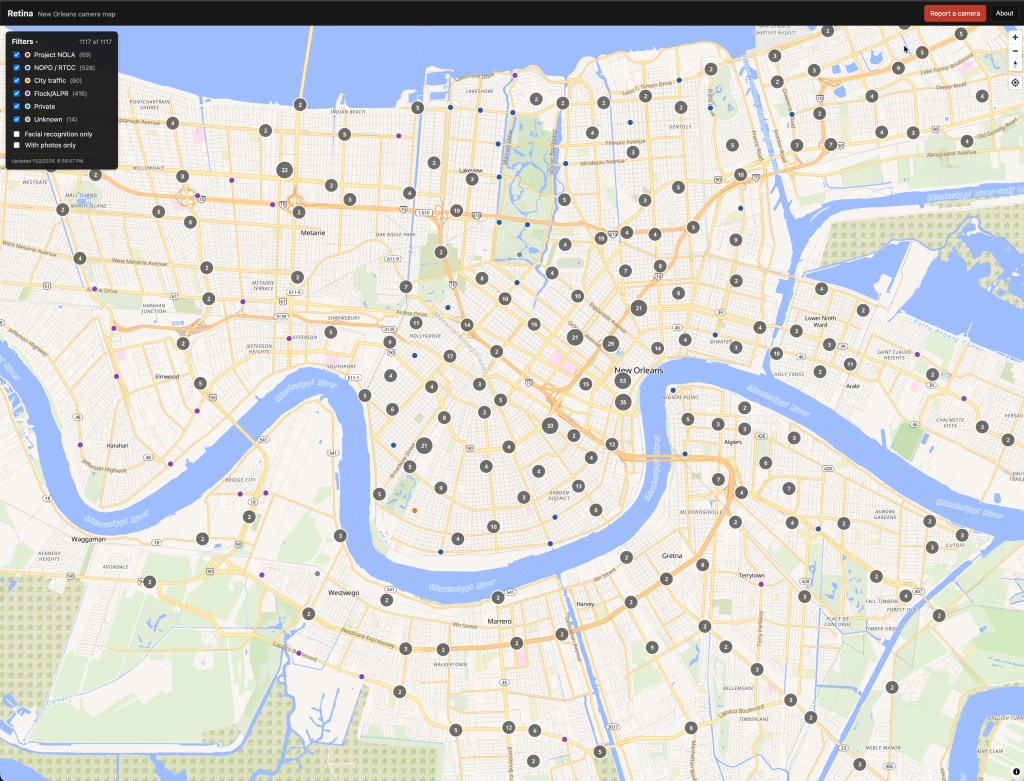
The Perdido Institute opened today, November 2, 2026, as a New Orleans nonprofit that protects residents from unlawful surveillance and holds city government to its own laws. Our first tool is RETINA, a public map of 1,117 surveillance cameras and automated license plate readers in New Orleans. We built it from two city datasets, OpenStreetMap, and reports from residents.
Perdido is Spanish for lost. Privacy includes the right to be lost: to walk through your own city without being identified, logged, and tracked. Perdido Street is also the address of City Hall, where most of our work is aimed.
What we do
The Institute runs five programs. Each one starts with public records and ends with a published finding, a formal complaint, or a resident who got an answer from a city agency.
- Surveillance accountability documents the cameras, facial recognition systems, license plate readers, and drones operating in New Orleans, and whether their use complies with city law.
- Police accountability files a complaint when records show an officer violating the law or NOPD policy, sends it to the Public Integrity Bureau (NOPD’s internal affairs unit), the Independent Police Monitor, and the Office of Inspector General, then publishes it and tracks what happens.
- Public records assistance files Louisiana Public Records Act requests, publishes the responses, and helps residents, journalists, and researchers file and appeal their own.
- City agency assistance helps residents get a response on 311 tickets, blight complaints, Sewerage and Water Board bills, and permits, and escalates when an agency does not answer.
- Evidence-based government tests the claims behind city public safety and technology spending against the data and publishes plain-language analysis for residents and policymakers.
Where this work started
The Institute grows out of work that our founder, Matthew Wollenweber, has published at insomniac.tech since 2025. Since July 2025 he has filed more than 100 complaints with the Public Integrity Bureau. Most of them concern NOPD officers asking Project NOLA, a private camera network that sent NOPD real-time facial recognition alerts until the department suspended them in April 2025, to find or track a person on its cameras.
Section 147-2 of the City Code limits NOPD’s use of facial recognition to a list of enumerated crimes, most of them violent, and states that it shall not be used as a surveillance tool. The City Council passed that ordinance on July 21, 2022.
The complaints, the public records productions of email between NOPD officers and Project NOLA, the analysis of NOPD drone flight logs, and the public records request templates all move to the Institute. The November 2025 production is the most recent example. The method stays the same. We get the records, publish them with sources, and file a complaint when the records show a violation. Earlier posts stay at insomniac.tech as an archive.
RETINA: a map of every camera we can find
RETINA is a public map of surveillance cameras and automated license plate readers in New Orleans. A license plate reader is a camera that photographs every passing plate and logs the time and place. Open the map and see what is watching your block.
As of November 2, 2026, the map holds 1,117 points: 528 NOPD and Real Time Crime Center cameras, 416 Flock and other automated license plate readers, 90 city traffic cameras, 69 suspected Project NOLA cameras, and 14 of unknown ownership. The Real Time Crime Center is the city’s camera monitoring hub. You can filter the map by operator, show only cameras flagged for facial recognition, or show only points with photos.
The data comes from four sources: the City’s traffic camera dataset on data.nola.gov, the City’s public safety camera map on nolagis.maps.arcgis.com, OpenStreetMap, and field reports from residents. We review every field report, with photos, before it appears on the map.
The Project NOLA points come from public records and our best effort to match those records to cameras in the field, so we call them suspected Project NOLA cameras. Every point on the map is a best-effort placement. Use the Street View link in a point’s popup to check it. If a camera is misidentified, missing, or placed wrong, email [email protected] or use Report a camera on the map. Records that confirm or correct any point go to the same address.
RETINA is self-hosted. When the map loads, your browser contacts two hosts: our server for the camera data and OpenFreeMap for the base map tiles. The map has no analytics, no trackers, and no account.
How to help
The Institute is volunteer-run. If you want to help with records research, field documentation of cameras, or policy work, write to [email protected]. If you have records about surveillance in New Orleans, send them. If you need help with a records request, a complaint, or a city agency that will not answer, ask.
If you want to do one thing today, open RETINA, find your block, and report the camera that is missing. Then sign the petition to stop illegal surveillance in New Orleans and send it to someone who lives here.
Matthew Wollenweber
Founder, The Perdido Institute

